Vector Layers: Styling, Geometry Editing and Attributes
Colouring DXF, KML, GeoJSON, Shapefile and NCN drawings on the map, correcting a drawing's shape, and reading CAD/GIS attributes by clicking.
2026-09-20 · 5 min read
Boundaries, parcels, alignments, survey points — anything expressed with lines enters CartaX as a vector layer. Uploading is not the end of it: the drawing has to be legible on the map, a wrong vertex has to be fixable, and the attribute data in the file must not be lost. This guide covers all three.
For which files are accepted and their size limits see Supported formats; for Netcad output see Importing a Netcad project.
Style: making a drawing legible against its background
The Style button in a vector layer's menu decides how the drawing looks on the map. Style is saved per layer: it survives reopening the project and appears the same way in a share.
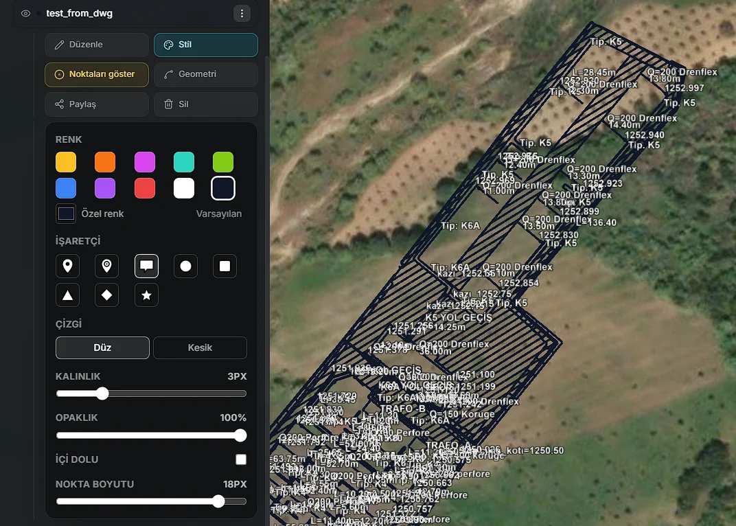
| Setting | Range |
|---|---|
| Colour | 10 presets, a custom colour picker and a reset to default |
| Marker | 8 icons: pin, location, note, circle, square, triangle, diamond, star |
| Line | Solid or dashed |
| Width | 1–10 pixels (default 2) |
| Opacity | 0–100% |
| Filled | Fills the interior of areas; fill transparency is set separately |
| Point size | 4–20 pixels (default 8) |
The panel adapts to the drawing's contents: marker and point size appear only for drawings that contain points, and "Filled" only for drawings that contain areas.
Three uses come up constantly:
- Making a drawing legible against its background — light colours on a dark orthophoto, dark colours on a light basemap.
- Separating layers in the same project by colour: boundary red, road yellow, utilities blue.
- Hide points to clear crowded survey points. This only hides unlabelled point markers — the hundreds that come out of a DXF, for instance; lines, areas and labelled points stay where they are.
Style applies to the whole layer. There is no automatic colouring by attribute value (thematic mapping).
Geometry editing: correcting a drawing's shape
If a vertex in an uploaded drawing is in the wrong place, you can correct it on the map. The Geometry button in the layer menu enters editing mode:
| Action | What it does |
|---|---|
| Drag a vertex | Moves it |
| Click a midpoint | Adds a new vertex |
| Right-click a vertex | Deletes it |
| ✓ / ✕ | Saves or discards |
While editing, the bottom of the screen shows which layer and how many vertices are being edited. The shape you confirm is saved to the layer.
Parcel boundaries cannot be edited. Parcel layers coming from a TKGM query have no Geometry button, and the save path rejects it too. This is deliberate: it prevents a cadastral boundary from being nudged by hand into something that looks like "the title deed boundary". A parcel's colour and line style are still changed through Style.
CartaX is not a CAD program: it corrects the shape of an existing drawing, it does not draw from scratch.
Attributes: the data in the file is not lost
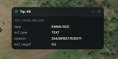
Click any element of a drawing and whatever the file holds about it is listed in a window:
- In a CAD drawing (DXF): layer name, entity type, rotation angle, text height
- In a parcel: province, district, neighbourhood, block, parcel, sheet, nature and area
- In a Shapefile: every column of the table
- In GeoJSON: the feature's
propertiesfields
The window can be moved. An element with no data says "No additional information for this element."
Attributes are read, not edited: the window shows what the file carries, it is not an attribute editor.
What you can do with a vector layer
| Action | Where |
|---|---|
| Rename | Layer menu → Rename |
| Colour and appearance | Style |
| Correct the shape | Geometry (absent on parcels) |
| Add to a share | Share — PIN-protected sharing |
| Create a route | Create route — on KML and parcel layers |
| Attach to analysis | As a card attachment in the analysis workspace |
| Delete | Delete — permanent, asks for confirmation |
Vector layers stay visible in both the 2D and 3D views of the map: opening or closing an orthophoto or a 3D model does not affect them.
FAQ
| Question | Answer |
|---|---|
| Does my styling show in a share? | Yes; style is saved to the layer |
| Is there colouring by attribute value? | No; style applies to the whole layer |
| Can I correct a parcel boundary? | No; parcels have no Geometry button |
| Can I change an attribute value? | No; the window is read-only |
| Hundreds of DXF points cover the map | Hide points — it hides unlabelled point markers |
| Does uploading vectors spend tokens? | No; they are processed in the browser, with no cloud step |