Route Planning: The Road to Site Starts Inside Your Project
Building a route in CartaX from project data, an address, a coordinate or a file; reading the distance and opening it in Google Maps as driving directions.
2026-09-20 · 5 min read
For anyone working with map data, "where is the site and how do I get there?" comes up on every job. Routes answer it inside the project: you pick a start and an end from project data, a file, an address, a coordinate or the map, and CartaX works out the route over drivable roads, calculates the distance and saves it. When you set off, one tap hands it to Google Maps.
Route creation is part of the Professional plan; it is not available on Free.
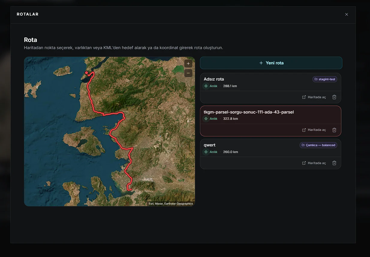
Three ways into the route screen
- The ROUTES column on the dashboard: the last three routes with their distances; All → or click a route
- Typing the route name in search (Ctrl + K)
- Create route from an orthophoto, KML or 3D model inside a project — the destination becomes that data's position and the route is bound to the project
A new route, step by step
- Press + New route on the route screen.
- Give it a name if you like (e.g. "Drive to site"). Left blank it becomes "Unnamed route".
- Choose the start point.
- Choose the end point.
- Calculate route — the path is drawn and the distance appears.
- Save to add it to the list. Cancel closes the form.
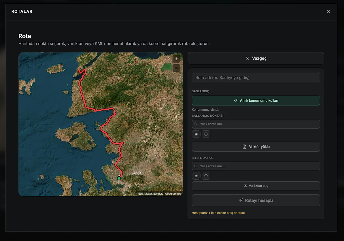
Six ways to pick a point
| Method | Where | Note |
|---|---|---|
| Use my current location | Start | Only when CartaX is installed as an app. The route starts from the device's current position on every calculation |
| Search a place / address | Either | Type a place name or address and pick from the suggestions |
| Enter a coordinate (#) | Either | Latitude and longitude in decimal degrees (e.g. 41.0151 and 28.9795); a comma works as the decimal separator too |
| Pick on the map | Either | Click a point with the crosshair on the map at left |
| Pick from an asset | End | First a project, then an orthophoto, KML or 3D model in it |
| Upload a vector | Depends on the file | KML, KMZ, GeoJSON, Shapefile (.zip), DXF or GeoTIFF |
When you upload a vector, the file's contents decide
- If the file contains an alignment (a line), the route is built directly from that line; no road routing is done and the distance is measured along the line.
- If there is no alignment (a point, an area or a GeoTIFF), the file's position becomes the end point; you choose a start and calculate. The file name is suggested as the route name.
- A file whose position cannot be verified is rejected: files with an unresolvable coordinate system, and DXFs that carry no geographic coordinates. CartaX will not produce a route that leads to the wrong place.
The saved route card
| Field | What it shows |
|---|---|
| Route name | "Unnamed route" if left blank |
| Project tag | The project name if the route is bound to one |
| Live / Fixed | Whether the route starts from the device's current position or a fixed point |
| Distance | Over drivable roads, in km |
| Clicking the card | Shows the route on the map at left and fits the map to it |
| Open in Maps | Opens the route in Google Maps as driving directions |
| Trash | Deletes the route |
On the map the route is drawn as a red line over satellite imagery; you pan by dragging and zoom with the wheel. Fit to route re-centres the map on the whole route.
Handing off to Google Maps
Open in Maps opens Google Maps as driving directions; on a phone with the Google Maps app installed, it opens there.
- The end point — and, on fixed-start routes, the start point — are handed over.
- On a live-start route, Google Maps begins from the device's current position.
- Directions open in driving mode.
- Google Maps calculates the path itself; it may not match the line in CartaX exactly. Intermediate points of an alignment taken from a file are not transferred, only its start and end.
Live start and warnings
- A live-start route shows a Live tag on its card.
- With such a route selected on the route screen, moving more than 150 metres recalculates the path automatically.
- Picking a point far from the road network (rural land, coastline, sea) produces a "no drivable road found nearby" warning.
- Starting from your current location works only in the installed app; in a browser tab the start is always a fixed point.
What it does not do
Knowing the limits makes clear what to expect:
- Only driving routes; there is no walking, cycling or heavy-vehicle profile.
- No waypoints — a route is one start and one end.
- No arrival time is shown; you get distance only.
- No in-app turn-by-turn navigation; directions are handed to Google Maps.
FAQ
| Question | Answer |
|---|---|
| Which plan? | Professional; not available on Free |
| What can the destination be? | Project data, a file, an address, a coordinate or a point on the map |
| Is travel time shown? | No; distance only (km) |
| Can I add waypoints? | No |
| Why is "current location" missing? | It appears only when CartaX is installed as an app |
| Is the alignment in my KML kept? | Yes; if there is a line the route is built from it directly |
| Google's path came out different | Google Maps calculates the route itself |